An ongoing initiative of ULI, Technical Assistance Panels (TAPs) provides strategic advice on complex land use and real estate development issues for local clients, such as municipalities, public agencies, and non-profit developers.
In early 2017, the City of Orinda reached out to ULI SF to assemble a multidisciplinary panel of experts who could aid in its efforts to initiate planning work for the community’s downtown district, asking the panel to provide “concrete and actionable” next steps.
Drawing from our seasoned professional membership base of 2,300, ULI SF composed a panel of professionals from a wide variety of disciplines reflecting diverse perspectives, including market analysis, land use and design, retail consulting, architecture, finance and development strategies, governance and policy, and real estate development. TAP Panelists included:
- David Cropper, Director of Development, TMG Partners (Panel Chair)
- Jessica von Brock, Assistant City Manager, City of Freemont
- Jeff Gee, Vice President, Swinerton Management & Consulting
- Geeti Siwal, Associate Principal, Perkins + Will
- Craig Semmelmeyer, Principal, Main Street Property Services
- David Shiver, Principal, BAE Urban Economics
- Megan Keith, Urban Planner, AECOM (TAP Writer/Designer)
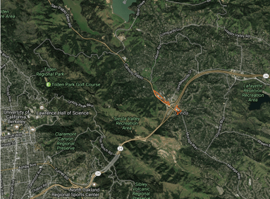
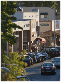
Regional context and image of Orinda’s downtown.
The City of Orinda, located east of Oakland on Highway 24, is a small community of 12.8 square miles and 18,400 people. Orinda has undertaken multiple downtown planning discussions, including a three-year effort that was paused in 2012. The City asked the TAP panel to help restart the “downtown conversation” and provide recommendations that they could implement while also building upon on the research and previously gathered input. Over the two-day working session, TAP panelists were asked to provide recommendations on the following four questions:
- Based on the interviews, what is the collective vision for downtown Orinda? Provide a draft mission statement for downtown.
- Based on the community’s vision for downtown Orinda, what streetscape design concepts, if any, are recommended?
- Based on the community’s vision for downtown Orinda, what are the restoration and planning recommendations, if any, for San Pablo Creek, a natural asset widely recognized to be under-utilized under current conditions.
- Based on the community’s vision for downtown Orinda, what changes, if any, are recommended to downtown development standards and allowable land uses?
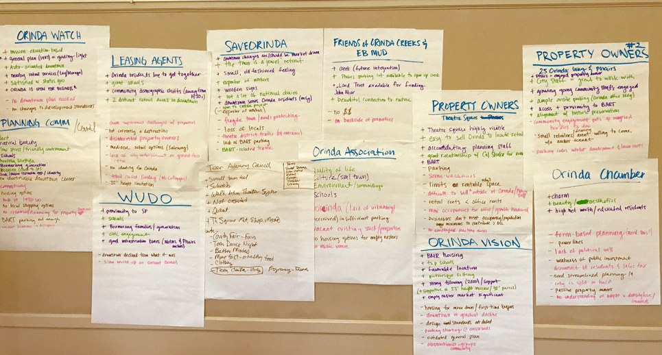
Notes taken during stakeholder interviews.
On April 10th and 11th, 2017, the TAP panelists gathered at the Orinda Community Center to interview a diverse cross-section of Orinda stakeholders to discuss their vision for the future of Orinda’s downtown. Stakeholders represented in the discussions included city staff, local elected officials, major property owners, local advocacy and community organizations made up of Orinda citizens, and Orinda business community representatives. The TAP panelists heard the following key themes from Orinda stakeholders:
- Orinda is a small, old-fashioned place with a “small-town” feel
- The high quality of Orinda’s school district is a major asset
- Orinda is an “oasis” and its natural resources are significant assets for the community
- The city is aging rapidly and its General Plan and corresponding land use policies are perceived to be outdated
- The building facades and character of Orinda’s downtown require immediate improvement
- The perceived shortage of parking is an issue that must be addressed
- The BART stop in Orinda is an asset, but also contributes to the need for additional parking policies and/or infrastructure
- Housing in Orinda is limited and excludes “boomerang” first-time homebuyers and also recent empty-nesters who would like to downsize their homes but continue to live in the community.
After hearing from the stakeholders, the panel synthesized the information received to present the following broad ideas, which can be read about in more detail in the full TAP report.
- Update Orinda’s General Plan in an inclusive way that is a true representation of Orinda’s unique character and history.
- Keep the process local and involve community members in all steps of the process.
- Create three downtown districts and one sub-district in Orinda:
- Village District – a walkable district with shops, possibly housing, active retail, and access to San Pablo Creek
- Civic District – the place where residents go for community services and events
- Crossroads District: the community’s place to hang out, eat, and shop
- Develop a San Pablo Creek Action Plan that focuses on the rehabilitation of San Pablo Creek.
- Provide new housing opportunities in downtown Orinda, including multi-unit projects and townhouses at a higher density than is allowed under the current zoning code or Orinda General Plan.
- Implement fast prototyping of new ideas to build community connectedness and establish a sense of place, including:
- Parklets, pop-up retail sites, and food trucks in the Crossroads and Village districts
- Landscaping and programming of the library arcade and the plaza between the library and Orinda Community Center (Civic District)
- Programming, such as events and spaces geared toward teens, art fairs, and books clubs (Civic District)
- Implement the existing “Downtown and Affected Neighborhoods Parking Study,” which was undertaken in 2016 by TJKM Parking Consultants and provides concrete actions to alleviate parking impacts, specifically overflow from the Orinda BART station, as well as the implementation of a parking permit program to reduce parking conflicts in residential areas that are adjacent to downtown districts.
- Implement parking district strategies.
Read the full Orinda TAP report to learn more about Orinda, the TAP methodology, and final recommendations.